About the Buonsignori Map
Little is known of Stefano Buonsignori (or Bonsignori) who designed the large axonometric ("birds-eye view") map of Florence displayed in the Gazetteer. He was an Olivetian monk (a local Tuscan order of Benedictines) skilled in map making, and near his convent (which is shown in the lower left hand corner of the map) was a panoramic view of Florence that may have helped to inspire his creation. He was employed by Grand Duke Francesco I as court "cosmographer" in January 1576 to help complete the series of painted maps of different parts of Europe begun by Egnazio Danti, who had been dismissed, in the Sala delle Carte Geografiche of the Uffizi. He later designed our panoramic view of Florence ("Nova pulcherrimae civitatis Florentiae topographia accuratissime delineata"). It was engraved by the Florentine goldsmith Bonaventura Billocardi and at least two copies were presented, one to Grand Duke Francesco I and the other to his brother Cardinal Ferdinando de Medici then living in Rome (who succeeded as duke in 1588), "so that far from the city [Your Lordship] will enjoy the sight of your fatherland" as the presentation letter of April 1585 read. Among the scientific instruments preserved in the Florentine Museo di Storia della Scienza are a solar quadrant with compass, three small portable sundials, and some other scientific instruments attributed to Buonsignori. He died in 1589.
Axonometric maps, or views, of cities were fairly common in the sixteenth century. Besides the great Jacopo de' Barberi map of Venice (ca. 1500), such maps exist for Rome (Bufalini 1551, Dosio 1561, Du Perac 1577), for Lyon (1548-52) and for other cities.(1) To accommodate the detail of buildings shown, the maps were in large format. Buonsignori's view of Florence in nine sheets (123 x 138 cm.), although nearly four feet square, was one of the smallest. The de' Barberi map of Venice in six sheets measured 134 x 282 cm., the Bufalini map of Rome in 24 sheets was 124 x 282 cm, and the 1548-52 map of Lyon with 25 sheets was 170 x 220 cm. The surveying techniques needed to make such maps were well known at least from the time of Leon Battista Alberti's Ludi matematici (ca. 1445). They involved the use of a quadrant (or transit) and compass with which sightings were made from elevated locations at different points. The angles and intersections of the plotted lines were duly noted for the map. The main points of orientation were thus systematically ascertained in the Buonsignori map, and although the sketches of individual buildings were impressionistic they were also based on observation. In the lower margin of the map we see Buonsignori himself, seated on a hill with his quadrant in hand.(2)
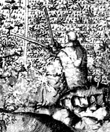
Buonsignori with his quadant
Only one copy of the initial 1584 map, in the Uffizi gallery, remains. Unfortunately, at an early point an attempt was made to colorize this copy, which along with some deterioration of the paper makes it difficult to see all the details. The coloration has been partly removed photographically for the available photographic reproductions,(3) and a smaller reproduction of this copy (roughly 63 x 69 cm.) was produced by the Florentine Istituto Geografico Militare in 1898 of which numerous copies remain. The smaller scale of the reproduction however also makes it difficult to see the details.
After Buonsignori's death the initial copper plates for his map came into the possession of a Sienese bookseller Girolamo Franceschi who prepared a new printing in 1594. Franceschi's edition re-engraved a few details: Duke Francesco I was now dead, and the cartouche with Buonsignori's dedication to him was replaced with the image of a seated woman representing peace; the Fortezza del Belvedere, begun in 1590, was added in its proper place; and on the Ponte Vecchio the word "Orefici" appears, because the earlier butcher and other shops on the bridge were expelled by Duke Ferdinando I in 1593 and jewelry shops were substituted; also the equestrian statue of Cosimo I, erected in the Piazza della Signoria in 1594, was added. Corresponding additions were made to the key of identified objects. In all other respects the 1594 edition of the map is exactly the same as the 1584 edition. There was also a seventeenth century Roman reprinting of the 1594 edition. (4) A copy of the initial 1594 edition appears to have been kept in Buonsignori's convent of Monte Oliveto whence it passed to the Museo Storico Topografico "Firenze com'era" where it is currently on display. This copy is clean, with some deterioration of the paper, and the details are clearly visible. With permission of the Museo we had new photographs made of their copy in the summer of 2005, on which what is shown in the Gazetteer in much greater and clearer detail than was earlier possible is based
For identified objects in the map, and our annotations, see: Notes on Using the Gazetteer.
(1) On the De Barberi map Juergen Schulz "The printed plans and panoramic views of Venice (1486-1797)" in Saggi e memorie di storia dell'arte. Florence, Olschki. VII (1970). For a general discussion: Jean Boutier, "L’Affirmation de la Cartographie Urbaine à Grande Échelle dans L’Europe de la Renaissance” In Per Un Atlante Storico Del Mezzogiorno e Della Sicilia. Omaggio a Bernard Lepetit. Eds. E. Iachello and B. Salvemini. Naples: Liguori, 1997. (Available online as: http://halshs.ccsd.cnrs.fr/halshs-00069762.) For the Buonsignori map and other early maps of Florence: Attilio Mori and Giuseppe Boffito, Firenze nelle vedute e piante. Studio storico topografico cartografico. Roma, Bonsignori: 1926, esp. pp. xxiii-xxiv, 40-44.
(2) On the development of mapping techniques: John A. Pinto, "Origins and Develolopment of the Ichnographic City Plan" in Journal of the Society of Architectural Historians 35(1976) pp. 35-50.
(3) Photographs (general and close-up) can be ordered from the Soprintendenza speciale per il polo museale Fiorentino, Gabinetto Fotografico, Piazzale degli Uffizi, 50122 Firenze, ITALY: their photograph numbers 99430 and 114920-114934.
(4) By Giovanni Jacopo (Giacomo) de Rossi, who had obtained the plates, "in Roma alla Pace" [all'insegna della Pace, 1660s-70s?]. This edition, of otherwise good quality, blanked out the cartouche with the seated woman. Copies are in Florence at the Istituto Geografico Militare Italiano and in Cambridge Mass., Harvard College Library (Map room 751.1690*).